Home
Find By Categories
Explore projects by categories
View All
Infrastructure & Construction
Construction Site Monitoring
Dam & Reservoir Surveillance
Energy & Utilities Monitoring
GIS & LiDAR
Infrastructure Assessments
Transport & Logistics
Urban Planning & Development
Surveys & Inspections
Mapping & GIS
Orthomosaics
Photogrammetry
Roof Inspections
Solar Inspection & Survey
Thermal Imaging
Topographic Survey
Tower Inspection
Real Estate
3D Virtual Tours
Commercial Real Estate
Investment Property
Large Estates & Mansions
Real Estate Photography
Residential Real Estate
Vacant Land
Explore services by categories
View All
Tourism & Travel
Adventure Tourism
Destination Marketing
Resort & Hotel Promotion
Agriculture & Farming
Agricultural Shows & Events
Crop Monitoring
Livestock Surveillance
Environmental & Conservation
Coastal & Marine Surveys
Disaster Assessments
Environmental Impact Studies
About Us
Explore projects by categories
View All
Infrastructure & Construction
Construction Site Monitoring
Dam & Reservoir Surveillance
Energy & Utilities Monitoring
GIS & LiDAR
Infrastructure Assessments
Transport & Logistics
Urban Planning & Development
Surveys & Inspections
Mapping & GIS
Orthomosaics
Photogrammetry
Roof Inspections
Solar Inspection & Survey
Thermal Imaging
Topographic Survey
Tower Inspection
Real Estate
3D Virtual Tours
Commercial Real Estate
Investment Property
Large Estates & Mansions
Real Estate Photography
Residential Real Estate
Vacant Land
Explore services by categories
View All
Tourism & Travel
Adventure Tourism
Destination Marketing
Resort & Hotel Promotion
Agriculture & Farming
Agricultural Shows & Events
Crop Monitoring
Livestock Surveillance
Environmental & Conservation
Coastal & Marine Surveys
Disaster Assessments
Environmental Impact Studies
How It Works
Explore projects by categories
View All
Infrastructure & Construction
Construction Site Monitoring
Dam & Reservoir Surveillance
Energy & Utilities Monitoring
GIS & LiDAR
Infrastructure Assessments
Transport & Logistics
Urban Planning & Development
Surveys & Inspections
Mapping & GIS
Orthomosaics
Photogrammetry
Roof Inspections
Solar Inspection & Survey
Thermal Imaging
Topographic Survey
Tower Inspection
Real Estate
3D Virtual Tours
Commercial Real Estate
Investment Property
Large Estates & Mansions
Real Estate Photography
Residential Real Estate
Vacant Land
Explore services by categories
View All
Tourism & Travel
Adventure Tourism
Destination Marketing
Resort & Hotel Promotion
Agriculture & Farming
Agricultural Shows & Events
Crop Monitoring
Livestock Surveillance
Environmental & Conservation
Coastal & Marine Surveys
Disaster Assessments
Environmental Impact Studies
Contact Us
Explore projects by categories
View All
Infrastructure & Construction
Construction Site Monitoring
Dam & Reservoir Surveillance
Energy & Utilities Monitoring
GIS & LiDAR
Infrastructure Assessments
Transport & Logistics
Urban Planning & Development
Surveys & Inspections
Mapping & GIS
Orthomosaics
Photogrammetry
Roof Inspections
Solar Inspection & Survey
Thermal Imaging
Topographic Survey
Tower Inspection
Real Estate
3D Virtual Tours
Commercial Real Estate
Investment Property
Large Estates & Mansions
Real Estate Photography
Residential Real Estate
Vacant Land
Explore services by categories
View All
Tourism & Travel
Adventure Tourism
Destination Marketing
Resort & Hotel Promotion
Agriculture & Farming
Agricultural Shows & Events
Crop Monitoring
Livestock Surveillance
Environmental & Conservation
Coastal & Marine Surveys
Disaster Assessments
Environmental Impact Studies
Distance in (Mile)
300
Pilots
Pilots
Services
Sign In
Register
All Categories
Agriculture & Farming
Drone Delivery services
Emergency Services
Events & Ceremonies
Infrastructure & Construction
Photography
Real Estate
Sporting Events
Surveys & Inspections
Al S
Home
Pilots
Al S
Categories
Aerial Inspections
Aerial Photography
Aerial Videography
Commercial Real Estate
Construction Site Monitoring
Interior photography
Investment Property
Large Estates & Mansions
Mixed Use Real Estate
Photography
Real Estate
Real Estate Photography
Residential Real Estate
Vacant Land
Virtual Staging
+6 more
Certifications
FAA Part-107 Licensed Drone Pilot #4381902
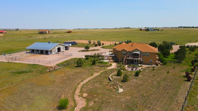
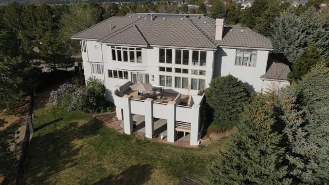
Services
Al S
Day Rates Photography by Above and Beyond Aerial Imaging
0
/5.0
User review
Mead, Colorado, US
Starting from
$849.00
Al S
Marketing Tools by Above and Beyond Aerial Imaging
0
/5.0
User review
Mead, Colorado, US
Starting from
$30.00
Al S
Upgrade edited HDR to HDR PRO (Hand Blended) photos
0
/5.0
User review
Mead, Colorado, US
Starting from
$1.00
Al S
Vacation Home Rentals Photography by Above and Beyond Aerial Imaging
0
/5.0
User review
Mead, Colorado, US
Starting from
$295.00
Al S
Virtual Staging by Above and Beyond Aerial Imaging
0
/5.0
User review
Mead, Colorado, US
Starting from
$65.00
Al S
Schematic Floor Plans by Above and Beyond Aerial Imaging
0
/5.0
User review
Mead, Colorado, US
Starting from
$25.00
Al S
3D Tours – Matterport by Above and Beyond Aerial Imaging
0
/5.0
User review
US
Starting from
$1.00
Al S
Interior, exterior and aerial Videography footage by Above and Beyond Aerial Imaging (120 Second)
0
/5.0
User review
US
Starting from
$350.00
Al S
Aerial Only Video by Above and Beyond Aerial Imaging
0
/5.0
User review
Mead, Colorado, US
Starting from
$145.00
1
2
Portfolio
Al Spina video
Al Spina video
Al Spina video
Al Spina video
1
2
Choose User Type
Add credit to your wallet
Add funds now
*
You will be redirected to the checkout page to add your billing details.
Add FAQ
Add title:
Add description:
Click “Save & Update” to update your faq
Save & Update
Reject service approval request
Send