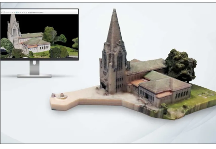
Hawaii Pacific Drone Solutions in Hawaii offers high-resolution 3D modeling services that bring your projects to life through “digital twins.” Using photogrammetry and advanced drone imaging, we create accurate, three-dimensional models of buildings, landscapes, and infrastructure. These digital twins replicate real-world environments in incredible detail, providing a powerful tool for analysis, planning, and visualization.
Developers, architects, and engineers can use 3D models to examine structures from every angle, monitor progress, and simulate future changes. Digital twins enhance collaboration between stakeholders by offering a shared, interactive view of a project. They also support asset management by documenting current conditions and helping to predict maintenance needs.
For construction, real estate, and urban planning, 3D modeling provides a more immersive understanding than traditional blueprints or photos. The result is improved efficiency, smarter decision-making, and reduced costs.
By combining aerial data collection with advanced modeling software, Hawaii Pacific Drone Solutions delivers cutting-edge visuals that support industries in achieving their goals with precision and clarity.
💲 Contact Hawaii Pacific Drone Solutions in Hawaii today to schedule your 3D modeling service and request a personalized quote.