
Our orthomosaic maps are perfect for various applications, offering precise, geo-referenced images that are invaluable for planning, analysis, and decision-making.
Service Features:
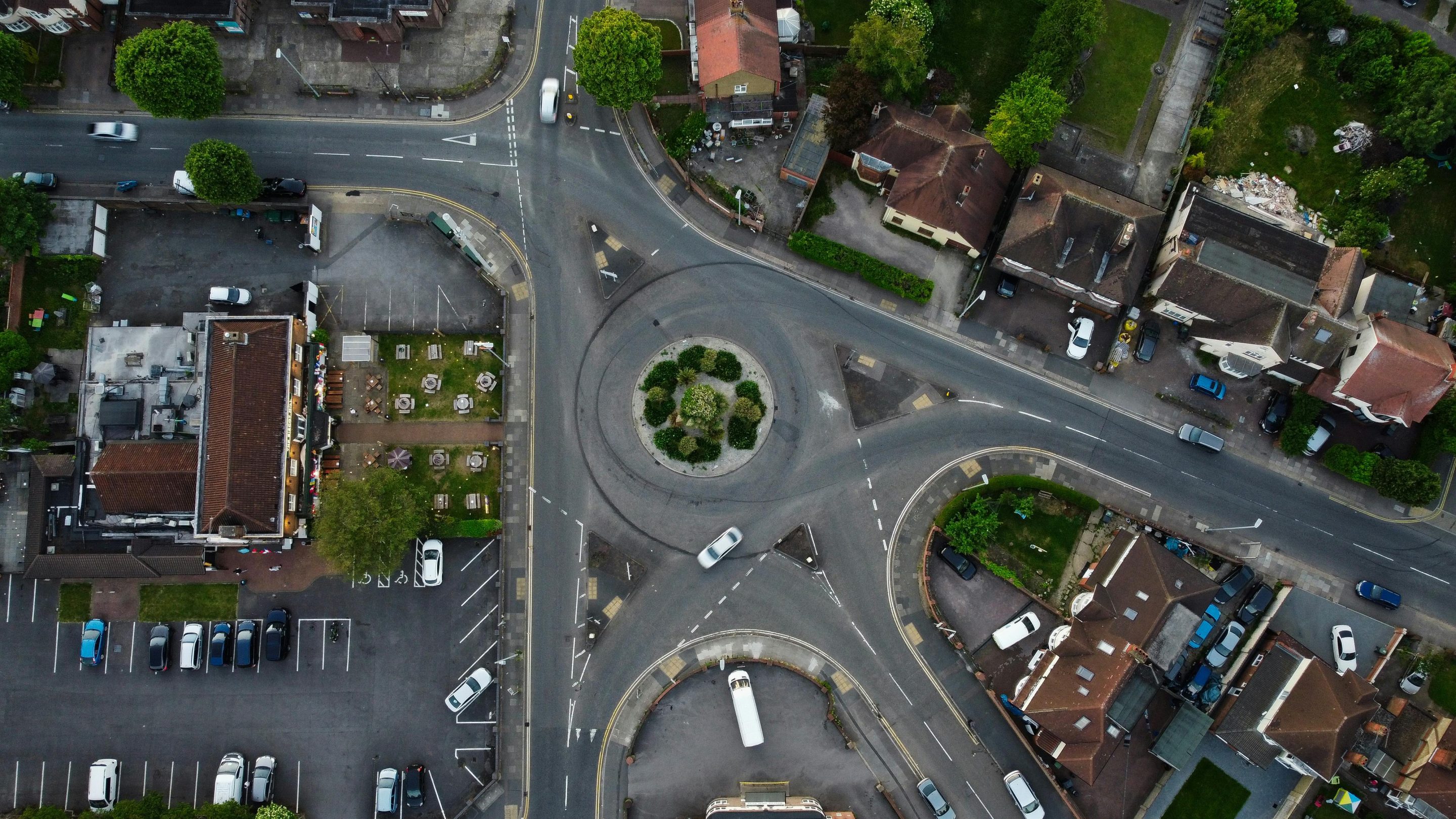
1. High-Resolution Imagery Our drones capture high-resolution aerial images, which are stitched together to create a seamless, accurate 2D orthomosaic map. This map provides detailed visual information of the entire area, allowing for precise analysis.
2. Georeferenced Data Each orthomosaic map is geo-referenced, meaning it is aligned with real-world coordinates. This ensures accuracy and allows for easy integration with other geographic information system (GIS) data.
3. Comprehensive Coverage We provide comprehensive coverage of the mapped area, ensuring no details are missed. Whether it’s a large construction site, agricultural field, or urban landscape, our orthomosaic maps cover every inch.
4. Fast Turnaround Our advanced processing techniques ensure that you receive your orthomosaic map quickly. We understand the importance of timely data, and we strive to deliver high-quality maps in a short timeframe.
5. Versatile Applications Our 2D orthomosaic mapping services are ideal for a wide range of applications, including:
- Construction Planning and Monitoring: Track progress, plan site layouts, and ensure compliance with regulations.
- Agricultural Management: Monitor crop health, plan irrigation, and assess field conditions.
- Environmental Monitoring: Track changes in landscapes, monitor wildlife habitats, and assess environmental impact.
- Urban Planning: Assist in planning and development of urban areas, infrastructure projects, and land use management.
6. Customizable Solutions We tailor our services to meet the specific needs of each client. Whether you require detailed maps of small areas or comprehensive coverage of large sites, we can customize our approach to deliver the best results.
7. User-Friendly Deliverables Our orthomosaic maps are delivered in user-friendly formats compatible with various GIS software. We ensure that you can easily access, view, and analyze the data for your specific needs.
Why Choose SkyScan Innovations?
- Expertise: Our team comprises experienced professionals with extensive knowledge in drone technology and aerial mapping.
- Quality: We are committed to delivering high-quality, accurate maps that meet your exact specifications.
- Reliability: Our services are dependable, ensuring you receive timely and precise data every time.
- Innovation: We continually invest in the latest drone technology and mapping software to provide cutting-edge solutions.
Orthomosaic Mapping, Photogrammetry, Aerial Imagery and other Drone services available in Indianapolis.
Contact us for more detailed pricing depending on acres.
Location
Fequently asked questions
What is a 2D orthomosaic map?
A 2D orthomosaic map is a high-resolution, georeferenced image created by stitching together multiple aerial photographs taken by a drone. This map provides an accurate, detailed representation of the mapped area, allowing for precise analysis and planning
What are the benefits of using drone 2D orthomosaic mapping?
Drone 2D orthomosaic mapping offers several benefits, including high accuracy, detailed imagery, comprehensive coverage, and fast turnaround times. It is a cost-effective and efficient solution for various applications, such as construction planning, agricultural management, and environmental monitoring.
How accurate are the orthomosaic maps?
The accuracy of orthomosaic maps depends on the resolution and the quality of the drone and camera equipment used. Our advanced drones and processing techniques ensure high accuracy, typically within a few centimeters.
What applications are suitable for 2D orthomosaic maps?
2D orthomosaic maps are suitable for a wide range of applications, including: - Construction planning and monitoring - Agricultural management and crop monitoring - Environmental monitoring and conservation - Urban planning and infrastructure development - Real estate and property management
How long does it take to produce a 2D orthomosaic map?
The time required to produce a 2D orthomosaic map depends on the size of the area and the complexity of the terrain. However, most projects are completed within a few days to a week, including data collection, processing, and delivery of the final map.
Do I need special software to view the orthomosaic maps?
Our orthomosaic maps are delivered in user-friendly formats that are compatible with various GIS software. You can view and analyze the maps using free or commercial GIS applications. We can also provide maps in formats compatible with standard image viewers.
Can orthomosaic maps be used for legal or official purposes?
Yes, orthomosaic maps can be used for various legal and official purposes, such as land surveys, environmental assessments, and construction planning. However, it is important to verify the specific requirements and regulations in your jurisdiction.
What equipment do you use for orthomosaic mapping?
We use state-of-the-art drones equipped with high-resolution cameras and advanced sensors to capture detailed aerial images. Our drones are capable of capturing high-quality data even in challenging conditions.
How much does a drone 2D orthomosaic mapping service cost?
The cost of a 2D orthomosaic mapping service depends on several factors, including the size of the area, the level of detail required, and any additional services requested. Our basic pricing ranges from $200 for small areas to $3,000 or more for large, complex projects. Contact us for a detailed quote based on your specific needs.
Is the mapping process affected by weather conditions?
Yes, weather conditions can affect the mapping process. Ideal conditions for drone mapping are clear skies and minimal wind. We may need to reschedule flights in cases of adverse weather to ensure the quality and accuracy of the data collected.
How do I schedule a 2D orthomosaic mapping service?
ou can schedule a service by contacting us via phone, email, or through our website. We will discuss your project requirements and arrange a convenient time for the mapping.
What if I need updates or additional mapping in the future?
We offer ongoing support and can provide regular updates or additional mapping services as needed. Whether you need seasonal agricultural assessments or progress monitoring for construction projects, we can accommodate your requirements.
How do you ensure the privacy and security of my property during the mapping process?
We adhere to strict privacy and security protocols to protect your property and data. Our drones are operated by certified professionals who follow all relevant regulations and guidelines.
Can you provide examples or case studies of previous projects?
Yes, we can provide examples and case studies of previous projects upon request. These examples showcase the quality and applications of our 2D orthomosaic mapping services.