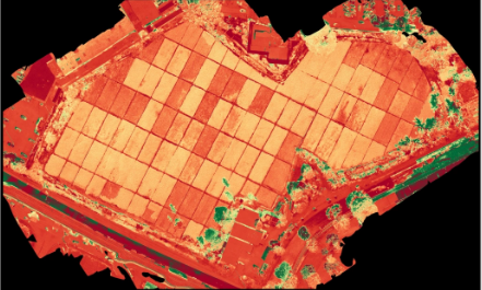

At Hawaii Pacific Drone Solutions in Hawaii, we support farmers and land managers with precision agriculture and land management services. By using drone technology, we capture aerial imagery that provides insights into crop health, soil conditions, irrigation efficiency, and land usage.
Multispectral and high-resolution imaging allows us to detect plant stress, monitor growth, and identify issues such as pests or disease before they spread. This data-driven approach empowers farmers to optimize resources, improve yields, and reduce costs.
Beyond agriculture, our drone services also support land conservation, forestry management, and environmental monitoring. With aerial mapping and analysis, we provide a comprehensive understanding of land conditions, helping clients make informed decisions for both productivity and sustainability.
By combining technology with agricultural expertise, Hawaii Pacific Drone Solutions delivers innovative solutions that meet the growing challenges of modern farming and land management.
💲 Contact Hawaii Pacific Drone Solutions in Hawaii today to schedule your precision agriculture service and request a custom quote.