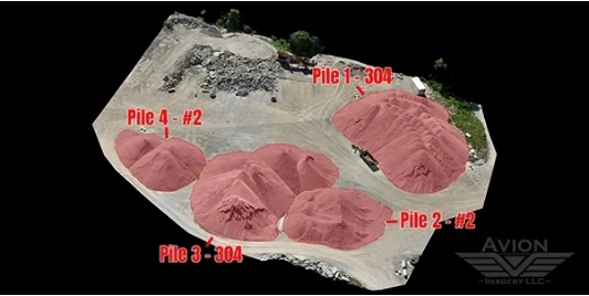
At Avion Imagery in Ohio, we provide accurate Stockpile Volume Measurement using drone-based mapping and photogrammetry. Our aerial surveys produce precise 3D models and volumetric calculations for aggregates, soil, mulch, coal, and other bulk materials—ensuring you always know what’s on site.
This method eliminates the guesswork of manual measurements and significantly reduces labor time. By flying over your stockpiles and processing the imagery with advanced software, we deliver accurate data you can trust for inventory tracking, reporting, and financial audits.
Our service is ideal for construction, mining, and material management industries, providing fast turnarounds and repeatable measurements that enhance accountability and planning.
💲 Pricing is custom—contact Avion Imagery in Ohio today for a personalized quote.