PAVING & ASPHALT INSPECTION by SkyVues UAS
-
0 sales
- 5 views
- 3 Hours Response time
- $0.00 No travel charge
- Save
0 /5.0
User review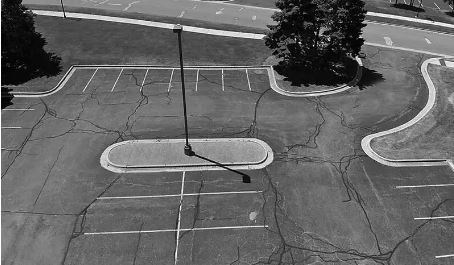

Drones are transforming the world of pavement engineering—delivering faster, more efficient,
and more accurate inspection results than ever before. Our aerial technology helps paving and
asphalt professionals document conditions, monitor progress, and plan remediation with confidence.
✅ Rapid Site Coverage
Drones can fly over large paved areas in a fraction of the time it takes traditional ground
crews—saving time and reducing labor costs.
✅ High-Resolution Imagery
Capture crisp, detailed “Before and After” visuals of pavement conditions for documentation,
presentations, or insurance purposes.
✅ 2D Site Modeling
Generate geometrically accurate 2D maps of parking lots, roads, and other paved surfaces.
Ideal for off-site planning and precise project analysis.
✅ Improve Planning & Decision-Making
Use aerial insights to identify trouble spots, monitor wear and tear, and develop effective
maintenance strategies before setting foot on site.
📩 Contact us today to schedule your paving or asphalt inspection and get high-quality aerial data you can trust.