Expert Aerial & Drone Photography for Construction Projects in Columbus, Ohio | Aroaerial
-
0 sales
- 222 views
- 3 Hours Response time
- $0.00 No travel charge
- Save
0 /5.0
User review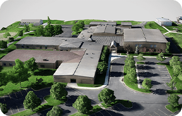


Aroaerial specializes in aerial photography and drone surveying services tailored specifically for construction projects in Columbus, Ohio. Utilizing advanced drone technology, we offer comprehensive solutions that gather valuable data and insights to enhance your construction endeavors.
Our experienced aerial/drone photographer employs high-resolution imaging capabilities to conduct detailed aerial surveys and create accurate 3D models of construction sites. Through our specialized drone mapping services, we generate precise topographic maps, ortho mosaic images, and digital elevation models, providing crucial information that supports effective project planning and monitoring.
Our range of services includes:
- Aerial Surveys: Capture comprehensive views of your construction sites to aid in planning and execution.
- Drone Mapping: Generate high-quality maps that are essential for tracking progress and making informed decisions.
- Construction Monitoring: Keep a close eye on project timelines and milestones with regular aerial assessments.
- Building Inspections: Conduct thorough inspections to identify issues early and ensure compliance with safety standards.
Whether you need assistance with progress monitoring, inspections, or detailed mapping, Aroaerial is your go-to partner for exceptional drone services in Columbus, Ohio. Contact us today to discover how our aerial photography and drone surveying solutions can elevate your construction projects!