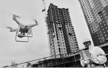
Drones are transforming the construction industry—improving safety, accuracy, and efficiency across the board. At SkyVues UAS, we provide advanced aerial data collection tailored specifically for construction professionals seeking smarter project insights and better results.
✅ Real-Time Site Monitoring
Gain up-to-date visuals of your job site. Our drone services allow teams to visualize the full project scope, collaborate remotely, and adapt plans based on current site conditions.
✅ Progress Tracking & Project Documentation
Recurring drone flights create a reliable visual timeline. Use aerial data to monitor development over time, enhance logistics, and keep stakeholders in the loop.
✅ Precision Measurements & Volumetric Analysis
Track material usage and equipment activity through accurate measurements. Analyze cut and fill volumes, compare progress to design plans, and make informed decisions on the fly.
✅ Safety & Cost Efficiency
Reduce hazardous man-hours with remote aerial inspections. We capture high-resolution imagery, video, and thermal data to detect damage or defects—minimizing risk and cost.
✅ Detailed Mapping & Modeling
Receive geometrically accurate 2D & 3D site models and stockpile measurements. Overlay data with topographic surveys for precise site analysis and planning.
📩 Contact SkyVues UAS today to discuss how we can support your next construction project with powerful aerial insights.
Travel upto 25 Miles