
Flyover Drone Services in Glendale, Arizona offers highly accurate aerial data solutions tailored specifically for surveyors and engineers. Our drone technology streamlines surveying workflows, improves measurement accuracy, and reduces time spent in the field. Using advanced photogrammetry, LiDAR, and GPS-enabled mapping systems, we produce precise orthomosaics, topographic maps, elevation models, and 3D site reconstructions that support a wide range of engineering and surveying applications.
Our services help professionals analyze terrain, conduct boundary assessments, measure site dimensions, track project progress, and validate design plans. Drones provide rapid large-area coverage, reducing manual surveying labor and increasing safety by eliminating the need to traverse difficult or hazardous terrain.
Engineers benefit from our data-rich models for planning, grading, drainage analysis, infrastructure assessments, and construction verification. Surveyors gain access to highly accurate geospatial information that enhances project efficiency and documentation quality.
With fast turnarounds, exceptional detail, and reliable accuracy, Flyover Drone Services supports both small and large-scale projects with confidence. Our aerial solutions empower industry professionals to work smarter, faster, and with superior precision.
Contact Flyover Drone Services for custom quotes.
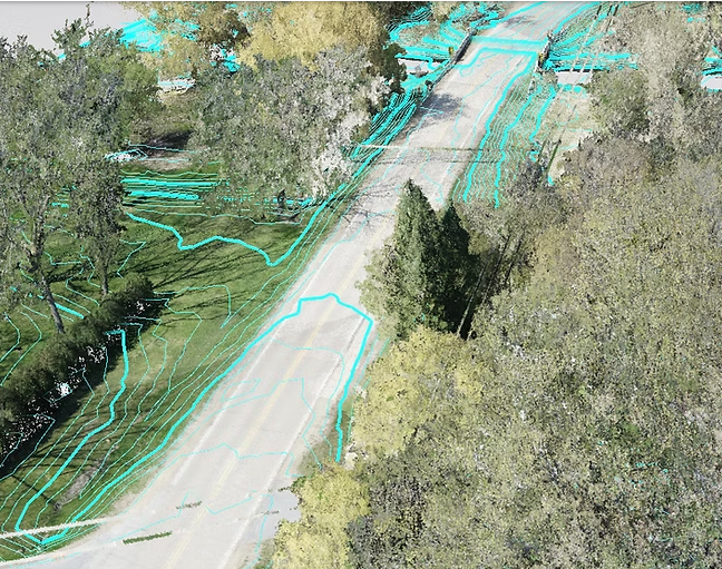
Get all the layers.
We fly with RTK precision and get the data layers you need:
-
Orthomosics
-
LiDAR Point Clouds
-
Point Cloud Classification
-
Digital Surface/Terrain Models (DSM/DTM)
-
TIN Surfaces
-
Contour Lines
-
3D models for BIM / As Builts