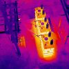
At MN Drone Pilot in Minnetrista, Minnesota, we provide advanced aerial thermal imaging services designed to identify temperature variances that are not visible to the naked eye. Using high-resolution thermal sensors, we capture accurate radiometric data to detect moisture intrusion, insulation gaps, electrical hotspots, heat leakage, HVAC inefficiencies, roof abnormalities, and structural anomalies. This service is highly beneficial for property managers, utility companies, facility maintenance teams, agricultural businesses, restoration contractors, and insurance professionals seeking fast, reliable diagnostic insights.
Our drone-based approach eliminates the need for risky manual inspections and large-scale physical access, making the evaluation process safer, faster, and more cost-efficient. Whether you require thermal imaging for commercial buildings, industrial plants, solar arrays, livestock monitoring, irrigation analysis, or residential assessments, we deliver actionable visual data that supports smarter decision-making. Imagery can be provided as photos, video, or temperature-mapped reporting depending on client requirements.
Thermal imaging is ideal for preventative maintenance, claim documentation, performance audits, and early problem detection, helping prevent costly future repairs. We maintain a professional workflow, safe UAV operations, and detailed data acquisition designed to meet industry standards.
📌contact MN Drone Pilot for a customized quote.

