
Discover how 3D Drone Modeling Columbus is transforming the way aerial data is captured and used. It represents the latest industry standard for detailed aerial analysis on construction and architectural projects.
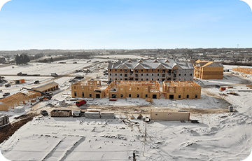
At Aroaerial, our drone 3D modeling services are reshaping the landscape of aerial photography and drone inspections. Utilizing cutting-edge technology and years of hands-on expertise, we deliver comprehensive 3D modeling solutions tailored specifically for construction sites and architectural projects across Ohio.
By deploying advanced drones, we capture high-resolution images and data from multiple angles and altitudes. This process enables the creation of detailed, accurate 3D models. Our drone mapping Columbus solutions facilitate precise construction site mapping, allowing architects and construction professionals to visualize and analyze their projects with exceptional accuracy.
Efficient and Cost-Effective UAV 3D Modeling
Through UAV 3D modeling, we offer an efficient, cost-effective alternative to traditional surveying methods. Our aerial mapping captures intricate details and terrain information, empowering clients to make informed decisions that improve project outcomes from planning through completion.
Expertise You Can Trust
As a leading drone photographer in Columbus, Ohio, we pride ourselves on delivering exceptional results. Our expertise in aerial 3D modeling for construction and architectural sites ensures you receive accurate, reliable data tailored to your project's specific needs. Choosing 3D Drone Modeling Columbus can make a measurable difference in your project's precision and success.
Contact Us Today
Experience the power of aerial technology in action. Contact Aroaerial today for unparalleled drone 3D modeling services and see how we can elevate your next project.